Greater Chicago Sunday School Association Certificates
- US-IlHpCH 2022.3-9-15.2
- File
- 1964-1977
2473 results with digital objects Show results with digital objects
Greater Chicago Sunday School Association Certificates
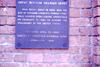
Depot plaque commemorating President Abraham Lincoln's 1861 "farewell" address in Illinois capital.
Part of Fort Sheridan Collection
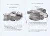
Gray National Telautograph Company : pp. iii-iv
Part of Elisha Gray Collection
Gray National Telautograph Company

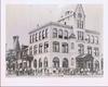
Gray National Telautograph Company : Cover
Part of Elisha Gray Collection
Gray National Telautograph Company
Part of Elisha Gray Collection
s.n.
Report on number of flags put on graves and whether a ceremony was held. Also includes leaflet on Things to do before a veteran dies.
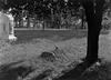
Grave of Anne Rutledge (Petersburg, Ill.)
Grave of Anne Rutledge (Petersburg, Ill.)
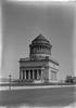
A black and white photograph taken of General Grant's tomb in Manhattan.