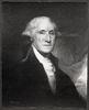
George Washington in 1772 as colonel of the Virginia Regiment/ painting by Charles Willson Peale
- US IlHpHS 1996.5-0189
- Item
- n.d.
The original oil on canvas by George Willson Peale is often described as the earliest portrait of George Washington. He is depicted in his Virginia Regiment uniform, painted in 1772.